Mitad Del Mundo (middle of the world)
Ecuador (equator in Spanish) is not located at the middle of the world. As luck would have it, when the French Geodesic Mission sought a place to try to figure out if the earth was flatter at the poles or equator, they picked Ecuador because they did not know enough about similarly located places (on the Equator) in Africa and Asia. Before you go any further, I strongly encourage you to listen to this 14 minute podcast from NOAA that discussed the role of geodesy in understanding the earth and in navigation.
It turned out that the same mission, led by Charles Marie de la Condamine made measurements and astronomical calculations to determine whether there was any real flattening or not. This led to the Metro Decimal System. The Metro is the 10 millionth part of a quadrant of the terrestrial meridian, which was measured by the same expedition. So, at least something came out of this mission.
THIS PAGE IS STILL UNDER DEVELOPMENT
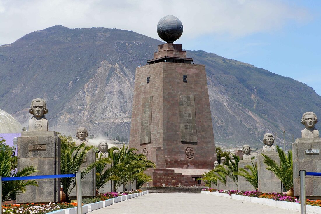
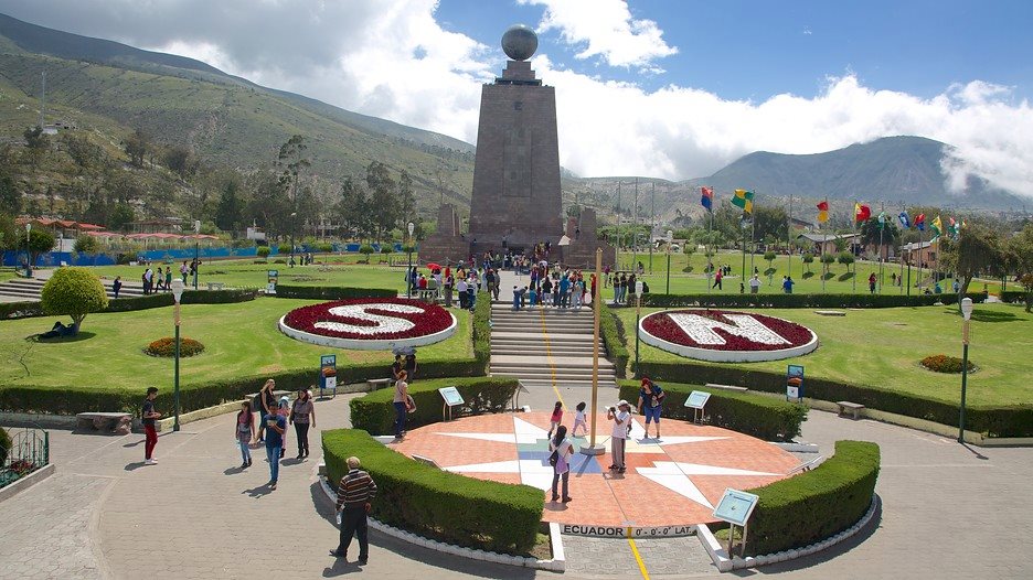
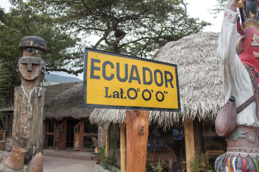
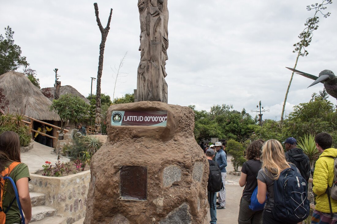
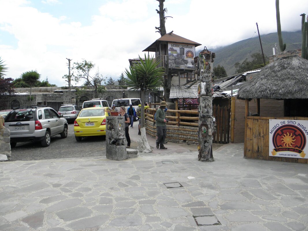
The French Geodesic Mission also calculated and placed the equatorial in an area within Pichincha Province, about 26 km north of Quito, the capital of Ecuador. This site was initially (in 1935) marked by a 10m monument that honored the French Expedition, and later (in 1972) by a 30m high monument titled “Ciudad Mitad del Mundo” (Middle of the World City). What is interesting about the 1972 monument is that it had already been shown by that time via the World Geodetic System and GPS that this site was not accurate (it was off by 240m). This did not stop the government of Pichincha Province from other construction between 1979 and 1982 that includes a small visitors center and museum at the French site. The local Native population had, in fact, already built their own monument (the Catequilla Ruins), now revamped, complete with their own museum, at latitude 0 (0°0′0″N 78°25′43″W). Ironically, the French had encountered these ruins between 1735 and 1745, but they did not make any link between them and their mission. Our trip visits the Native Museum (Intinan Solar Museum) because it is a lot more interesting.
THIS PAGE IS STILL IN DEVELOPMENT
THIS PAGE IS STILL IN DEVELOPMENT
Projection Systems
The PDF files attached at the end of this section discuss map projections in great detail. We are discussing map projections in this course because of the oversized role the country of Ecuador played in early geographical mapping explorations (due to its location).
|
|
| ||||||||
Why most of Ecuador is not as hot as other Equatorial regions
It's all about relief (topography). Most of the country is on high elevation. This is a good excuse to study a bit of Ecuador geography. Most of the following content is summarized from Britannica.
The Ecuadoran mainland is divided into three main physical regions: the Costa (coastal region), the Sierra (highland region), and the Oriente (eastern region). The Costa is composed of lowlands that extend eastward from the Pacific Ocean to the western edge of the Andes and rise from sea level to an elevation of 1,650 feet (500 metres). Running north-south, small coastal mountain ranges—the Colonche, Chindul, and Mache mountains—rise to 2,600 feet (800 metres). Between these coastal ranges and the Andes, interior valleys are mantled with silt deposits left by rivers that largely drain into the Gulf of Guayaquil. Puná, in the gulf, is the major island.
The Ecuadoran mainland is divided into three main physical regions: the Costa (coastal region), the Sierra (highland region), and the Oriente (eastern region). The Costa is composed of lowlands that extend eastward from the Pacific Ocean to the western edge of the Andes and rise from sea level to an elevation of 1,650 feet (500 metres). Running north-south, small coastal mountain ranges—the Colonche, Chindul, and Mache mountains—rise to 2,600 feet (800 metres). Between these coastal ranges and the Andes, interior valleys are mantled with silt deposits left by rivers that largely drain into the Gulf of Guayaquil. Puná, in the gulf, is the major island.
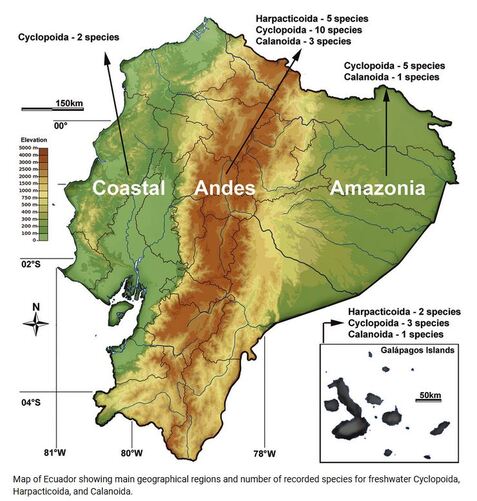
The Sierra includes two high mountain chains and their western and eastern foothills. The western and central ranges of the Andes bordering the Sierra constitute the country’s highest and most continuous mountain chains. Many peaks are volcanic or snow-covered; these include Cayambe (18,996 feet [5,790 metres]), Antisana (18,714 feet [5,704 metres]), Cotopaxi, which is one of the world’s highest active volcanoes (19,347 feet [5,897 metres]), Chimborazo (20,702 feet [6,310 metres]), Altar (17,451 feet [5,319 metres]), and Sangay (17,158 feet [5,230 metres]). These are included in two ranges connected at intervals by transversal mountain chains, between which are large isolated valleys or basins, called hoyas.
To the east of the main ranges are peaks Reventador (11,434 feet [3,485 metres]) and Sumaco (12,759 feet [3,889 metres]); the Cordillera de Cutucú, which borders the Upano valley and includes the central peaks; and the Cordillera del Cóndor to the south, which borders the Zamora valley. Beyond this eastern cordillera, to the east, is the Amazon basin, extending below 900 feet (300 metres).
The volcanic Galapagos Islands consist of 19 rugged islands and scores of islets and rocks situated about 600 miles (900 km) west of the mainland. The largest island, Isabela (Albemarle), rises to 5,541 feet (1,689 metres) at Mount Azul, the archipelago’s highest point. The second largest island is Santa Cruz.
ClimateBecause Ecuador lies on the Equator, most of the country, except the Sierra, experiences a humid tropical climate. The Oriente is influenced throughout the year by an unstable maritime tropical air mass, while the Costa is subject to greater variations associated with seasonal movements of the intertropical convergence zone and the cold Peru Current. Local convectional processes dominate the weather in the higher parts of the Andes.
The Oriente experiences fairly continuous and abundant rainfall and high temperatures. The Costa generally has a wet season in the first half of the year and a relatively dry one in the second half. In some years, warm water collects off the coast, causing the weather phenomenon known as El Niño; this can result in torrential downpours that cause devastating ecological damage on the coast and occasionally even in the highlands. In the Sierra, rains reach a maximum during the equinoxes; there is a long dry season from June to September and a shorter one (the veranillo) from December through January.
Ecuador has a small area of truly dry climate at the Santa Elena Peninsula along the southern coast, with annual rainfall decreasing from about 40 inches (1,000 mm) near Guayaquil to only 4 inches (100 mm) at Salinas. In the highlands, annual rainfall decreases toward the centres of the canyons and valleys, sometimes dropping below 20 inches (500 mm) or even below 10 inches (250 mm). Most of the country, however, is humid, receiving more than 20 inches of rain a year. The southern coast and the highlands receive 30 to 80 inches (760 to 2,000 mm). The wettest areas, the northern coast and the Oriente, receive about 120 to 240 inches (3,000 to 6,000 mm) of rain.
Both the Costa and the Oriente are warm, with temperatures varying only slightly among the seasons; much wider differences occur between day and night. Average daytime high temperatures range from 84 to 91 °F (29 to 33 °C), while nighttime lows fall to between 68 and 75 °F (20 to 24 °C). As elevation increases, temperatures drop fairly predictably at a rate of about 9 to 11 °F (5 to 6 °C) for every 3,300 feet (1,000 metres). Pleasantly temperate climates occur between elevations of 2,600 and 6,600 feet (800 and 2,000 metres). At higher elevations, frost is a possibility, especially in areas of flat relief and during the cloud-free nights of the dry seasons. Above elevations of 11,800 to 12,500 feet (3,600 to 3,800 metres), agriculture becomes increasingly difficult because of the shrinking growing season and increasing frost hazard. Above 16,400 feet (5,000 metres) the peaks are snowcapped.
